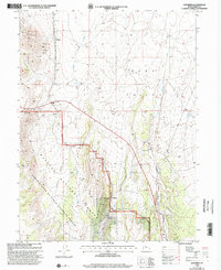
1998 Map of Lofgreen
USGS Topo · Published 2002About this map
Lofgreen sits at the base of the mountains in Tooele County, marking a vital point of intersection between the high country and the broad expanse of Rush Valley. This landscape is defined by its transition from the structured drainages of Brush Creek and Dog Hollow Creek to the open ranching and grazing lands. The presence of several family-named landmarks, such as Pehrson and Dunbar, along with Cummings Well, suggests a history of localized settlement centered on water access and livestock management. Portions of the map are Administered by Uinta National Forest, where the terrain climbs into the steep draws of Sharpes Valley. The network of 4wd tracks and numerous prospect pits and a quarry near the Vernon Hills indicate a history of small-scale mineral exploration and resource extraction typical of the eastern Great Basin range.
Find a feature on this map
25 named features on this map. Tap any name to fly to it.
Don’t see what you’re looking for? This feature index may not catch every label — zoom into the map to look around manually.
Map Details
Editions of this 1998 Lofgreen Map
This is the sole edition of this map. No revisions or reprints were ever made.
Other maps of this area

1885 · Sevier Desert
USGS Topo · 1:250,000

1885 · Tooele Valley
USGS Topo · 1:250,000

1947 · Fivemile Pass
USGS Topo · 1:62,500

1947 · Boulter Peak
USGS Topo · 1:24,000

1949 · Fivemile Pass
USGS Topo · 1:24,000

1953 · Tooele
USGS Topo · 1:250,000

1953 · Delta
USGS Topo · 1:250,000

1954 · Tintic Junction
USGS Topo · 1:24,000

1955 · Tooele
USGS Topo · 1:250,000

1958 · Delta
USGS Topo · 1:250,000