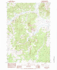
1983 Map of Logan Butte
USGS Topo · Published 1983About this map
Logan Butte and the surrounding rangelands of Crook County dominate this landscape, reflecting the isolation and livestock-focused economy of central Oregon in the early 1980s. The map detailing this high-desert terrain reveals a network of working ranches and seasonal camps, including the 96 Ranch, Q Ranch Corral, and the curious Pot Hook Place. For those interested in the natural history of the region, the inclusion of a Fossil Bed near Cherry Gulch provides a specific point of interest within the volcanic topography.
Find a feature on this map
33 named features on this map. Tap any name to fly to it.
Don’t see what you’re looking for? This feature index may not catch every label — zoom into the map to look around manually.
Map Details
Editions of this 1983 Logan Butte Map
This is the sole edition of this map. No revisions or reprints were ever made.
Other maps of this area

1951 · Post
USGS Topo · 1:62,500

1955 · Crescent
USGS Topo · 1:250,000

1955 · Bend
USGS Topo · 1:250,000

1957 · Crescent
USGS Topo · 1:250,000

1957 · Bend
USGS Topo · 1:250,000

1958 · Crescent
USGS Topo · 1:250,000

1958 · Bend
USGS Topo · 1:250,000

1970 · Crescent
USGS Topo · 1:250,000

1981 · Prineville
USGS Topo · 1:100,000

1982 · Arrowwood Point
USGS Topo · 1:24,000