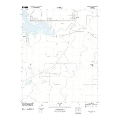
2010 Map of Logan South
USGS Topo · Published 2010About this map
Logan anchors this 2010 survey of Quay County, where the semi-arid landscape is defined by the massive impoundment of the Canadian River at the Ute Dam. This infrastructure created the Ute Reservoir, a central feature of the local geography that serves both as a water source and a recreation hub, with development spreading along South Shore Dr and State Park Rd. Away from the water, the map reveals a sparsely populated ranching and agricultural expanse, dotted with family-named landmarks like Hendricks Place, White Ranch, and Cummings Place. The layout of rural life is visible through a network of section-line roads, including Quay Road 70 and Quay Road Y, connecting isolated points of interest such as the Sullinger Windmill and several water wells like the Stansbury Well. The presence of the Logan Post Office and Ute Dam Airport highlights the town's role as a regional service center for this high plains territory.
Find a feature on this map
34 named features on this map. Tap any name to fly to it.
Don’t see what you’re looking for? This feature index may not catch every label — zoom into the map to look around manually.
Map Details
Editions of this 2010 Logan South Map
This is the sole edition of this map. No revisions or reprints were ever made.
Other maps of this area

1930 · Tucumcari
USGS Topo · 1:125,000

1954 · Tucumcari
USGS Topo · 1:250,000

1958 · Tucumcari
USGS Topo · 1:250,000

1962 · Logan
USGS Topo · 1:62,500

1968 · Porter
USGS Topo · 1:24,000

1968 · Hudson
USGS Topo · 1:24,000

1968 · San Jon NW
USGS Topo · 1:24,000

1968 · Lesbia
USGS Topo · 1:24,000

1968 · Montesito Creek
USGS Topo · 1:24,000
1989 · Tuscocoillo Canyon
USGS Topo · 1:24,000