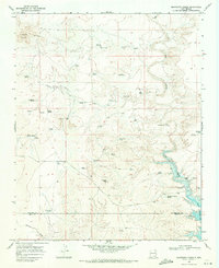
1968 Map of Montesito Creek
USGS Topo · Published 1971About this map
Ute Creek winds through this arid landscape of the High Plains, feeding into the northern reaches of the Ute Reservoir near the border of Harding and Quay Counties. The 1968 field survey reveals a network of water-dependent infrastructure essential for ranching and settlement in this semi-arid region, including numerous family-named landmarks like Martinez Windmill and Betties Windmill.
Find a feature on this map
44 named features on this map. Tap any name to fly to it.
Don’t see what you’re looking for? This feature index may not catch every label — zoom into the map to look around manually.
Map Details
Editions of this 1968 Montesito Creek Map
2 editions found
Historical Maps of Harding County Through Time
212 maps found

1966 Cottonwood Springs
Harding County, NM

1966 Mc Carty Ranch
Harding County, NM

1966 Mc Cloy Ranch
Harding County, NM

1966 Pedernal Creek
Harding County, NM

1966 Rosebud
Harding County, NM

1968 Montesito Creek
Harding County, NM

1969 Buffalo Springs
Harding County, NM

1969 Fuentes Ranch
Harding County, NM

1969 Gallegos
Harding County, NM

1969 Gallegos NE
Harding County, NM

1969 Salitre Canyon
Harding County, NM

1971 Abbott Lake
Harding County, NM

1971 Beaver Canyon
Harding County, NM

1971 Canon Encierro
Harding County, NM

1972 Mills West
Harding County, NM

1973 Albert
Harding County, NM

1973 Arroyo Del Alamo
Harding County, NM

1973 Bueyeros
Harding County, NM

1973 Bueyeros NE
Harding County, NM

1973 Circle Bar Ranch
Harding County, NM

1973 Indian Bathtub
Harding County, NM

1973 Minnie Butte
Harding County, NM

1973 Sabino
Harding County, NM

1973 Valencia Spring
Harding County, NM

1973 Yates SE
Harding County, NM

1974 Divine Lake
Harding County, NM

1974 Kansas Valley
Harding County, NM

1974 Kansas Valley Lake
Harding County, NM

1974 Mills East
Harding County, NM

1974 Solano
Harding County, NM

1974 Spear Hills
Harding County, NM

1977 Beenham SW
Harding County, NM

1978 La Cinta Canyon
Harding County, NM

1989 Logan North
Harding County, NM

1998 Abbott Lake
Harding County, NM

1998 Beaver Canyon
Harding County, NM

1998 Divine Lake
Harding County, NM

1998 Kansas Valley
Harding County, NM

1998 Mills East
Harding County, NM

1998 Mills West
Harding County, NM

1998 Spear Hills
Harding County, NM

1998 Valencia Spring
Harding County, NM

2010 Albert
Harding County, NM

2010 Arroyo Del Alamo
Harding County, NM

2010 Beenham SW
Harding County, NM

2010 Bueyeros
Harding County, NM

2010 Bueyeros NE
Harding County, NM

2010 Buffalo Springs
Harding County, NM

2010 Canon Encierro
Harding County, NM

2010 Circle Bar Ranch
Harding County, NM

2010 Cottonwood Springs
Harding County, NM

2010 Fuentes Ranch
Harding County, NM

2010 Gallegos
Harding County, NM

2010 Gallegos NE
Harding County, NM

2010 Indian Bathtub
Harding County, NM

2010 Kansas Valley Lake
Harding County, NM

2010 La Cinta Canyon
Harding County, NM

2010 Logan North
Harding County, NM

2010 McCarty Ranch
Harding County, NM

2010 McCloy Ranch
Harding County, NM

2010 Minnie Butte
Harding County, NM

2010 Montesito Creek
Harding County, NM

2010 Pedernal Creek
Harding County, NM

2010 Rosebud
Harding County, NM

2010 Sabino
Harding County, NM

2010 Salitre Canyon
Harding County, NM

2010 Solano
Harding County, NM

2010 Yates SE
Harding County, NM

2011 Abbott Lake
Harding County, NM

2011 Beaver Canyon
Harding County, NM

2011 Divine Lake
Harding County, NM

2011 Kansas Valley
Harding County, NM

2011 Mills East
Harding County, NM

2011 Mills West
Harding County, NM

2011 Spear Hills
Harding County, NM

2011 Valencia Spring
Harding County, NM

2013 Abbott Lake
Harding County, NM

2013 Albert
Harding County, NM

2013 Arroyo Del Alamo
Harding County, NM

2013 Beaver Canyon
Harding County, NM

2013 Beenham SW
Harding County, NM

2013 Bueyeros
Harding County, NM

2013 Bueyeros NE
Harding County, NM

2013 Buffalo Springs
Harding County, NM

2013 Canon Encierro
Harding County, NM

2013 Circle Bar Ranch
Harding County, NM

2013 Cottonwood Springs
Harding County, NM

2013 Divine Lake
Harding County, NM

2013 Fuentes Ranch
Harding County, NM

2013 Gallegos
Harding County, NM

2013 Gallegos NE
Harding County, NM

2013 Indian Bathtub
Harding County, NM

2013 Kansas Valley
Harding County, NM

2013 Kansas Valley Lake
Harding County, NM

2013 La Cinta Canyon
Harding County, NM

2013 Logan North
Harding County, NM

2013 McCarty Ranch
Harding County, NM

2013 McCloy Ranch
Harding County, NM

2013 Mills East
Harding County, NM

2013 Mills West
Harding County, NM

2013 Minnie Butte
Harding County, NM

2013 Montesito Creek
Harding County, NM

2013 Pedernal Creek
Harding County, NM

2013 Rosebud
Harding County, NM

2013 Sabino
Harding County, NM

2013 Salitre Canyon
Harding County, NM

2013 Solano
Harding County, NM

2013 Spear Hills
Harding County, NM

2013 Valencia Spring
Harding County, NM

2013 Yates SE
Harding County, NM

2017 Abbott Lake
Harding County, NM

2017 Albert
Harding County, NM

2017 Arroyo Del Alamo
Harding County, NM

2017 Beaver Canyon
Harding County, NM

2017 Beenham SW
Harding County, NM

2017 Bueyeros
Harding County, NM

2017 Bueyeros NE
Harding County, NM

2017 Buffalo Springs
Harding County, NM

2017 Canon Encierro
Harding County, NM

2017 Circle Bar Ranch
Harding County, NM

2017 Cottonwood Springs
Harding County, NM

2017 Divine Lake
Harding County, NM

2017 Fuentes Ranch
Harding County, NM

2017 Gallegos
Harding County, NM

2017 Gallegos NE
Harding County, NM

2017 Indian Bathtub
Harding County, NM

2017 Kansas Valley
Harding County, NM

2017 Kansas Valley Lake
Harding County, NM

2017 La Cinta Canyon
Harding County, NM

2017 Logan North
Harding County, NM

2017 McCarty Ranch
Harding County, NM

2017 McCloy Ranch
Harding County, NM

2017 Mills East
Harding County, NM

2017 Mills West
Harding County, NM

2017 Minnie Butte
Harding County, NM

2017 Montesito Creek
Harding County, NM

2017 Pedernal Creek
Harding County, NM

2017 Rosebud
Harding County, NM

2017 Sabino
Harding County, NM

2017 Salitre Canyon
Harding County, NM

2017 Solano
Harding County, NM

2017 Spear Hills
Harding County, NM

2017 Valencia Spring
Harding County, NM

2017 Yates SE
Harding County, NM

2020 Abbott Lake
Harding County, NM

2020 Albert
Harding County, NM

2020 Arroyo Del Alamo
Harding County, NM

2020 Beaver Canyon
Harding County, NM

2020 Beenham SW
Harding County, NM

2020 Bueyeros
Harding County, NM

2020 Bueyeros NE
Harding County, NM

2020 Buffalo Springs
Harding County, NM

2020 Canon Encierro
Harding County, NM

2020 Circle Bar Ranch
Harding County, NM

2020 Cottonwood Springs
Harding County, NM

2020 Divine Lake
Harding County, NM

2020 Fuentes Ranch
Harding County, NM

2020 Gallegos
Harding County, NM

2020 Gallegos NE
Harding County, NM

2020 Indian Bathtub
Harding County, NM

2020 Kansas Valley
Harding County, NM

2020 Kansas Valley Lake
Harding County, NM

2020 La Cinta Canyon
Harding County, NM

2020 Logan North
Harding County, NM

2020 McCarty Ranch
Harding County, NM

2020 McCloy Ranch
Harding County, NM

2020 Mills East
Harding County, NM

2020 Mills West
Harding County, NM

2020 Minnie Butte
Harding County, NM

2020 Montesito Creek
Harding County, NM

2020 Pedernal Creek
Harding County, NM

2020 Rosebud
Harding County, NM

2020 Sabino
Harding County, NM

2020 Salitre Canyon
Harding County, NM

2020 Solano
Harding County, NM

2020 Spear Hills
Harding County, NM

2020 Valencia Spring
Harding County, NM

2020 Yates SE
Harding County, NM

2023 Abbott Lake
Harding County, NM

2023 Albert
Harding County, NM

2023 Arroyo Del Alamo
Harding County, NM

2023 Beaver Canyon
Harding County, NM

2023 Beenham SW
Harding County, NM

2023 Bueyeros
Harding County, NM

2023 Bueyeros NE
Harding County, NM

2023 Buffalo Springs
Harding County, NM

2023 Canon Encierro
Harding County, NM

2023 Circle Bar Ranch
Harding County, NM

2023 Cottonwood Springs
Harding County, NM

2023 Divine Lake
Harding County, NM

2023 Fuentes Ranch
Harding County, NM

2023 Gallegos
Harding County, NM

2023 Gallegos NE
Harding County, NM

2023 Indian Bathtub
Harding County, NM

2023 Kansas Valley
Harding County, NM

2023 Kansas Valley Lake
Harding County, NM

2023 La Cinta Canyon
Harding County, NM

2023 Logan North
Harding County, NM

2023 McCarty Ranch
Harding County, NM

2023 McCloy Ranch
Harding County, NM

2023 Mills East
Harding County, NM

2023 Mills West
Harding County, NM

2023 Minnie Butte
Harding County, NM

2023 Montesito Creek
Harding County, NM

2023 Pedernal Creek
Harding County, NM

2023 Rosebud
Harding County, NM

2023 Sabino
Harding County, NM

2023 Salitre Canyon
Harding County, NM

2023 Solano
Harding County, NM

2023 Spear Hills
Harding County, NM

2023 Valencia Spring
Harding County, NM

2023 Yates SE
Harding County, NM