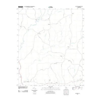
2011 Map of Logtown
USGS Topo · Published 2011About this map
Auchumpkee Creek Covered Bridge stands as a landmark over Auchumpkee Creek in this rural landscape of Upson County. This region is characterized by a high density of family and community burial grounds, illustrating a deep history of settlement and kinship across the countryside. Small communities like Salem and Logtown serve as anchors among a network of rural routes such as Triune Mill Rd and Wilmot Mill Rd, which suggest the agricultural and milling history of the area. The landscape is defined by the drainage basins of Tobler Creek, Little Creek, and Bailey Branch, where the terrain transitions between creek bottoms and the low ridges occupied by legacy sites like Salem Cemetery and Bethlehem Cemetery. The presence of numerous named cemeteries, including Gatlin Cemetery and Arnold Cemetery, provides a dense map of historical family footprints for those researching the genealogy of this portion of Georgia.
Find a feature on this map
46 named features on this map. Tap any name to fly to it.
Don’t see what you’re looking for? This feature index may not catch every label — zoom into the map to look around manually.
Map Details
Editions of this 2011 Logtown Map
This is the sole edition of this map. No revisions or reprints were ever made.
Other maps of this area

1935 · Thomaston
USGS Topo · 1:48,000

1939 · Thomaston
USGS Topo · 1:62,500

1951 · Yatesville
USGS Topo · 1:62,500

1955 · Phenix City
USGS Topo · 1:250,000

1957 · Phenix City
USGS Topo · 1:250,000

1958 · Phenix City
USGS Topo · 1:250,000

1971 · Prattsburg
USGS Topo · 1:24,000
1971 · Lincoln Park
USGS Topo · 1:24,000

1971 · Fickling Mill
USGS Topo · 1:24,000
1971 · Thomaston
USGS Topo · 1:24,000