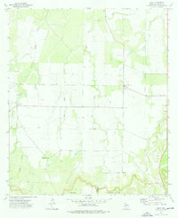
1973 Map of Lohn
USGS Topo · Published 1976About this map
Lohn and Pear Valley anchor this central Texas landscape, where the northern slopes of the Brady Mountains descend into a network of creek forks. This 1970s survey captures the agricultural and ranching character of the region, featuring a system of property boundaries marked by fine red dashed lines that indicate selected fence lines. The rural infrastructure is well-defined, ranging from the Athletic Field and Lohn Cem near the town center to isolated Well sites and Gravel Pits that suggest local industry.
Find a feature on this map
21 named features on this map. Tap any name to fly to it.
Don’t see what you’re looking for? This feature index may not catch every label — zoom into the map to look around manually.
Map Details
Editions of this 1973 Lohn Map
This is the sole edition of this map. No revisions or reprints were ever made.
Other maps of this area

1892 · Eden
USGS Topo · 1:125,000

1894 · Brady
USGS Topo · 1:125,000

1896 · Eden
USGS Topo · 1:125,000

1924 · Eden 1-a
USGS Topo · 1:48,000

1924 · Brady 2-a
USGS Topo · 1:48,000

1925 · Brady 2-b
USGS Topo · 1:48,000

1928 · Waldrip
USGS Topo · 1:62,500

1931 · Stacy
USGS Topo · 1:62,500

1954 · Brownwood
USGS Topo · 1:250,000

1960 · West Sweden
USGS Topo · 1:24,000