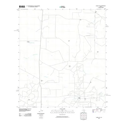
2010 Map of Loma Alta
USGS Topo · Published 2010About this map
Loma Alta serves as a central landmark in this South Texas landscape, where the petroleum industry and cattle ranching shape the terrain. Extensive energy operations are evident through the Hagist Ranch Oil Field, the Seven Sisters Oil Field, and the Eagle Hill Oil Field, supported by the Hagist Ranch Gas Plant. These industrial sites are interspersed among historical family holdings such as Hagist Ranch and Foster Ranch. Drainage is defined by the winding paths of San Jose Creek and Drummond Creek, which flow through the brush country. Prominent elevations like Loma Pinta and the presence of Walker Lake with its Walker Lake Dam illustrate the local reliance on water management in an area characterized by scattered rural settlements like Seven Sisters.
Find a feature on this map
25 named features on this map. Tap any name to fly to it.
Don’t see what you’re looking for? This feature index may not catch every label — zoom into the map to look around manually.
Map Details
Editions of this 2010 Loma Alta Map
This is the sole edition of this map. No revisions or reprints were ever made.
Other maps of this area

1920 · Mikeska
USGS Topo · 1:125,000

1937 · Loma Alta
USGS Topo · 1:62,500

1953 · Crystal City
USGS Topo · 1:250,000

1955 · Crystal City
USGS Topo · 1:250,000

1956 · Rosita Ranch
USGS Topo · 1:62,500

1956 · Freer
USGS Topo · 1:62,500

1956 · Laredo
USGS Topo · 1:250,000

1961 · Crystal City
USGS Topo · 1:250,000

1968 · Crystal City
USGS Topo · 1:250,000
1969 · Loma Alta NE
USGS Topo · 1:24,000