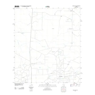
2013 Map of Loma Alta
USGS Topo · Published 2013About this map
The Hagist Ranch Oil Field and Seven Sisters Oil Field dominate this portion of the South Texas brush country, illustrating the region's enduring energy economy. Scattered ranching outposts such as Hagist Ranch and Foster Ranch are connected by a network of rural roads, including FM-624 and Walker Rd. Water sources are sparse but critical to the landscape, with Charco Valiente Spring providing a natural focal point amidst seasonal drainages like Drummond Cr and San Jose Cr. The settlement of Seven Sisters lies near the southern edge of the quadrangle, while the namesake Loma Alta and the prominent Loma Pinta rise above the drainage of Black Cr. Industrial infrastructure is visible through features like the Hagist Ranch Gas Plant, showing how the land has been utilized for both livestock and mineral extraction in McMullen County.
Find a feature on this map
22 named features on this map. Tap any name to fly to it.
Don’t see what you’re looking for? This feature index may not catch every label — zoom into the map to look around manually.
Map Details
Editions of this 2013 Loma Alta Map
This is the sole edition of this map. No revisions or reprints were ever made.
Other maps of this area

1920 · Mikeska
USGS Topo · 1:125,000

1937 · Loma Alta
USGS Topo · 1:62,500

1953 · Crystal City
USGS Topo · 1:250,000

1955 · Crystal City
USGS Topo · 1:250,000

1956 · Rosita Ranch
USGS Topo · 1:62,500

1956 · Freer
USGS Topo · 1:62,500

1956 · Laredo
USGS Topo · 1:250,000

1961 · Crystal City
USGS Topo · 1:250,000

1968 · Crystal City
USGS Topo · 1:250,000
1969 · Loma Alta NE
USGS Topo · 1:24,000