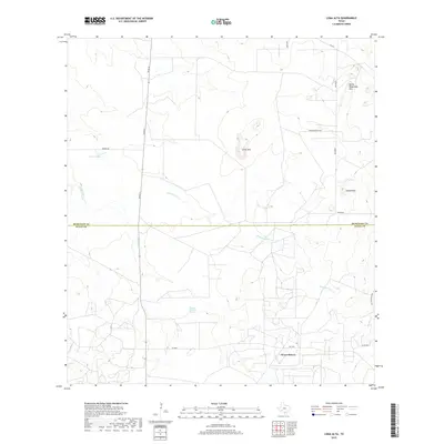
2019 Map of Loma Alta
USGS Topo · Published 2019About this map
The settlement of Seven Sisters anchors the southern portion of this South Texas landscape, situated at the junction of FM 2359 and River ST. The topography is defined by prominent elevations such as Loma Alta and the Devils Waterhole Hills, which rise above the surrounding brush country. This area, straddling the boundary between McMullen and Duval Counties, exhibits a drainage pattern characterized by intermittent waterways like San Jose Creek and Drummond Creek. The presence of Charco Valiente Spring and Walker Lake indicates critical water sources in an otherwise arid environment. Ranching infrastructure is evident through named thoroughfares such as Atkinson Ranch Rd and Walker Rd, while the eastern edge is traced by the Old San Diego Rd, suggesting historical transit corridors through the scrublands.
Find a feature on this map
18 named features on this map. Tap any name to fly to it.
Don’t see what you’re looking for? This feature index may not catch every label — zoom into the map to look around manually.
Map Details
Editions of this 2019 Loma Alta Map
This is the sole edition of this map. No revisions or reprints were ever made.
Other maps of this area

1920 · Mikeska
USGS Topo · 1:125,000

1937 · Loma Alta
USGS Topo · 1:62,500

1953 · Crystal City
USGS Topo · 1:250,000

1955 · Crystal City
USGS Topo · 1:250,000

1956 · Rosita Ranch
USGS Topo · 1:62,500

1956 · Freer
USGS Topo · 1:62,500

1956 · Laredo
USGS Topo · 1:250,000

1961 · Crystal City
USGS Topo · 1:250,000

1968 · Crystal City
USGS Topo · 1:250,000
1969 · Loma Alta NE
USGS Topo · 1:24,000