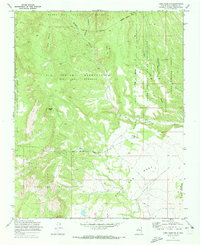
1970 Map of Loma Creston
USGS Topo · Published 1973About this map
Santa Ana Indian Reservation and the surrounding ancestral lands define this high desert landscape, which was meticulously field-checked in 1970. The terrain is marked by dramatic geological formations such as Santa Ana Mesa and Loma Creston, where the interplay of mesas and deeply cut drainages like Borrego Canyon shaped historic movement through the region. This 1970s record captures the complex intersection of land grants and reservation boundaries, including the Zia Indian Reservation Ojo Del Borrego Grant Boundary and the Santo Domingo Pueblo Indian Reservation. Significant landmarks like Bodega Butte and the intermittent flow of Arroyo Bodega provide specific navigational points for researchers studying the geographic heritage of the San Ysidro and Jemez Valley vicinity. The map also delineates the southern reaches of the Santa Fe National Forest, documenting the overlap of federal and tribal land management at the time.
Find a feature on this map
17 named features on this map. Tap any name to fly to it.
Don’t see what you’re looking for? This feature index may not catch every label — zoom into the map to look around manually.
Map Details
Editions of this 1970 Loma Creston Map
2 editions found
Other maps of this area

1888 · Bernalillo
USGS Topo · 1:125,000

1889 · Albuquerque
USGS Topo · 1:125,000

1890 · Jemes
USGS Topo · 1:125,000

1892 · San Pedro
USGS Topo · 1:125,000

1892 · Jemes
USGS Topo · 1:125,000

1892 · Santa Clara
USGS Topo · 1:125,000

1893 · Albuquerque
USGS Topo · 1:125,000

1943 · Jemez
USGS Topo · 1:62,500

1952 · Jemez
USGS Topo · 1:62,500

1953 · Santo Domingo Pueblo SW
USGS Topo · 1:24,000