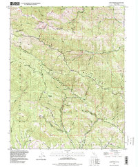
1996 Map of Loma Prieta
USGS Topo · Published 1999About this map
The San Andreas Fault Zone dominates this 1996 view of the borderlands between Santa Clara and Santa Cruz counties. The landscape is defined by its deep canyons and elevated peaks, notably Loma Prieta and the Sierra Azul range. This survey reveals a complex network of waterways, including Uvas Creek and Corralitos Creek, which carve through the terrain. Evidence of the region’s earlier land divisions is preserved in the Pueblo Lands of San Jose and the Los Corralitos boundaries. While largely defined by its natural topography, the map records established routes such as Highland Way and Buzzard Lagoon Road that traverse the ridges. Settlements like Loma Chiquita are sparse, indicating the area's role as a transition between more developed valleys and the rugged interior of the Santa Cruz Mountains.
Find a feature on this map
30 named features on this map. Tap any name to fly to it.
Don’t see what you’re looking for? This feature index may not catch every label — zoom into the map to look around manually.
Map Details
Editions of this 1996 Loma Prieta Map
This is the sole edition of this map. No revisions or reprints were ever made.
Other maps of this area

1912 · Capitola
USGS Topo · 1:62,500

1914 · Capitola
USGS Topo · 1:62,500

1915 · San Juan Bautista
USGS Topo · 1:48,000

1916 · New Almaden
USGS Topo · 1:48,000

1917 · Morgan Hill
USGS Topo · 1:62,500

1917 · San Juan Bautista
USGS Topo · 1:62,500

1919 · New Almaden
USGS Topo · 1:62,500

1939 · Morgan Hill
USGS Topo · 1:62,500

1939 · San Juan Bautista
USGS Topo · 1:62,500

1940 · San Juan Bautista
USGS Topo · 1:62,500