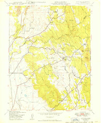
1949 Map of Loma Rica
USGS Topo · Published 1949About this map
Loma Rica and its surrounding foothills are defined by a complex network of water management and mining history at the close of the 1940s. Irrigation systems such as the Mahle Ditch and Browns Valley Ditch illustrate the region's agricultural dependency on channeled water, while the Sweet Vengeance Mine and the nearby Smethurst Mine (Abandoned) point to the area's geological extraction roots. Educational centers like Fruitland Union Sch and Kings Sch serve as focal points for rural communities like Sunnyslope and Iowa City. The terrain transitions from the elevations of Browns Valley Ridge down toward the drainages of North Honcut Creek and South Honcut Creek, where early cemeteries like Honcut Cem mark the heritage of Yuba and Butte counties.
Find a feature on this map
34 named features on this map. Tap any name to fly to it.
Don’t see what you’re looking for? This feature index may not catch every label — zoom into the map to look around manually.
Map Details
Editions of this 1949 Loma Rica Map
This is the sole edition of this map. No revisions or reprints were ever made.
Other maps of this area

1888 · Marysville
USGS Topo · 1:125,000

1888 · Smartsville
USGS Topo · 1:125,000

1891 · Marysville
USGS Topo · 1:125,000

1891 · Smartsville
USGS Topo · 1:125,000

1892 · Smartsville
USGS Topo · 1:125,000

1894 · Smartsville
USGS Topo · 1:125,000

1894 · Marysville
USGS Topo · 1:125,000

1895 · Marysville
USGS Topo · 1:125,000

1895 · Smartsville
USGS Topo · 1:125,000

1911 · Browns Valley
USGS Topo · 1:31,680