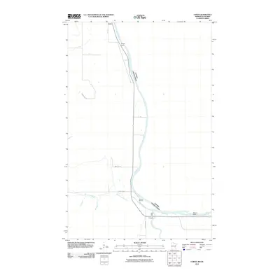
2010 Map of Loman
USGS Topo · Published 2010About this map
The Canada-United States border follows the centerline of the Rainy River in this northern Minnesota landscape. This borderland is defined by the confluence of several water bodies, where the Black River and the West Fork Black River meet the international waterway. The small settlement of Loman serves as a local hub near the southern bank, containing the Loman Post Office and providing access to the river's various islands, including Smoot Island to the north and Watrous Island to the east. Further upriver, the settlement of Indus occupies a bend in the water. The presence of Riverside Cemetery near the riverbank suggests a long-standing community presence in this wooded corridor, where early road networks like County Hwy 82 and Black River Rd trace the path of the water.
Find a feature on this map
14 named features on this map. Tap any name to fly to it.
Don’t see what you’re looking for? This feature index may not catch every label — zoom into the map to look around manually.
Map Details
Editions of this 2010 Loman Map
This is the sole edition of this map. No revisions or reprints were ever made.
Other maps of this area

1919 · Pelland
USGS Topo · 1:62,500

1919 · Happy Land
USGS Topo · 1:62,500

1943 · Lindford
USGS Topo · 1:62,500

1954 · International Falls
USGS Topo · 1:250,000

1957 · International Falls
USGS Topo · 1:250,000

1958 · International Falls
USGS Topo · 1:250,000

1970 · Devlin
USGS Topo · 1:24,000
1970 · Lindford
USGS Topo · 1:24,000
1970 · Manitou
USGS Topo · 1:24,000
1970 · Lindford NW
USGS Topo · 1:24,000