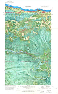
1970 Map of Manitou
USGS Topo · Published 1973About this map
Manitou and Burton sit along the international border in northern Minnesota, separated from Ontario by the Rainy River. This 1970 orthophotomap provides a rare combination of aerial imagery and topographic data, capturing the intricate network of seasonal paths such as the Winter Trail and various Winter routes that navigate the boggy lowland terrain. The landscape is defined by its water systems, including the Manitou Rapids and the meandering West Fork Black River which flows through the southern portion of the sheet.
Find a feature on this map
15 named features on this map. Tap any name to fly to it.
Don’t see what you’re looking for? This feature index may not catch every label — zoom into the map to look around manually.
Map Details
Editions of this 1970 Manitou Map
This is the sole edition of this map. No revisions or reprints were ever made.
Other maps of this area

1919 · Birchdale
USGS Topo · 1:62,500

1919 · I
USGS Topo · 1:62,500

1943 · Lindford
USGS Topo · 1:62,500

1954 · Roseau
USGS Topo · 1:250,000

1954 · International Falls
USGS Topo · 1:250,000

1957 · Roseau
USGS Topo · 1:250,000

1957 · International Falls
USGS Topo · 1:250,000

1958 · International Falls
USGS Topo · 1:250,000

1958 · Roseau
USGS Topo · 1:250,000

1968 · Birchdale SE
USGS Topo · 1:24,000