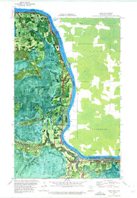
1970 Map of Loman
USGS Topo · Published 1973About this map
The Rainy River forms a dominant natural boundary between Minnesota and Ontario in this 1970 orthophotomap, which combines traditional topographic lines with aerial imagery. The settlement of Loman serves as a focal point along the southern bank, where the Loman Sch and Riverside Cem are situated near the river’s bend. To the west, the smaller community of Indus and its High Sch mark the settled edge of the wilderness.
Find a feature on this map
22 named features on this map. Tap any name to fly to it.
Don’t see what you’re looking for? This feature index may not catch every label — zoom into the map to look around manually.
Map Details
Editions of this 1970 Loman Map
This is the sole edition of this map. No revisions or reprints were ever made.
Other maps of this area

1919 · Pelland
USGS Topo · 1:62,500

1919 · Happy Land
USGS Topo · 1:62,500

1943 · Lindford
USGS Topo · 1:62,500

1954 · International Falls
USGS Topo · 1:250,000

1957 · International Falls
USGS Topo · 1:250,000

1958 · International Falls
USGS Topo · 1:250,000

1970 · Devlin
USGS Topo · 1:24,000
1970 · Lindford
USGS Topo · 1:24,000
1970 · Manitou
USGS Topo · 1:24,000
1970 · Lindford NW
USGS Topo · 1:24,000