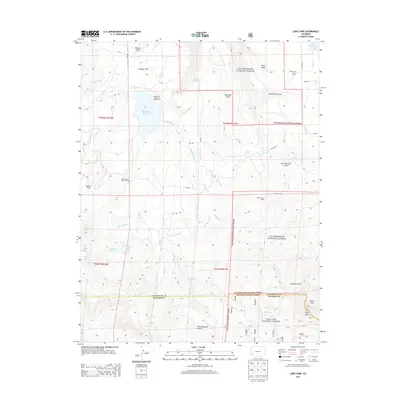
2013 Map of Lone Cone
USGS Topo · Published 2013About this map
Miramonte Reservoir and the high-elevation livestock camps of the Uncompahgre National Forest define this landscape in the early twenty-first century. This territory, situated along the border of San Miguel and Dolores counties, illustrates a complex network of water management through the Lillylands Canal and Lillylands Intake, designed to move water across the plateau from sources like Lillylands Reservoir. The presence of Redd Ranchs Summer Camp, Barrett Cow Camp, and Piele Lone Cone Camp reflects the continued importance of seasonal grazing in the San Juan Mountains. The terrain transitions from the open stretches of Greager Flats and Nellies Flats to the prominent peak of Lone Cone in the southeast, a landmark that towers over West Naturita Creek and the surrounding timberlands.
Find a feature on this map
48 named features on this map. Tap any name to fly to it.
Don’t see what you’re looking for? This feature index may not catch every label — zoom into the map to look around manually.
Map Details
Editions of this 2013 Lone Cone Map
This is the sole edition of this map. No revisions or reprints were ever made.
Other maps of this area

1956 · Cortez
USGS Topo · 1:250,000

1956 · Moab
USGS Topo · 1:250,000

1958 · Cortez
USGS Topo · 1:250,000

1959 · Cortez
USGS Topo · 1:250,000

1959 · Moab
USGS Topo · 1:250,000

1960 · Moab
USGS Topo · 1:250,000

1962 · Moab
USGS Topo · 1:250,000

1962 · Cortez
USGS Topo · 1:250,000

1964 · Moab
USGS Topo · 1:250,000
1964 · Groundhog Reservoir
USGS Topo · 1:24,000