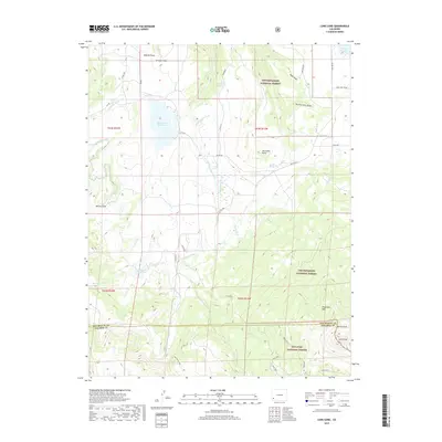
2019 Map of Lone Cone
USGS Topo · Published 2019About this map
Lone Cone towers over the high country where the boundaries of San Miguel Co and Dolores Co meet. This 2019 survey documents a landscape defined by complex water management and the transition between the Uncompahgre National Forest and San Juan National Forest. Water is diverted across the high plateaus through systems like the Lillylands Canal and Last Chance Ditch, feeding significant upland bodies including Miramonte Reservoir and Lilylands Reservoir. The terrain names suggest a history of grazing and ranching, with features like Greager Flats, Nellies Flats, and the descriptive Beef Trail Rd marking old routes and open ranges. Smaller, more isolated landmarks like Preachers Hole and the Devils Chair provide specific points of interest for those tracing the traditional place names of this corner of the Colorado mountains.
Find a feature on this map
51 named features on this map. Tap any name to fly to it.
Don’t see what you’re looking for? This feature index may not catch every label — zoom into the map to look around manually.
Map Details
Editions of this 2019 Lone Cone Map
This is the sole edition of this map. No revisions or reprints were ever made.
Other maps of this area

1956 · Cortez
USGS Topo · 1:250,000

1956 · Moab
USGS Topo · 1:250,000

1958 · Cortez
USGS Topo · 1:250,000

1959 · Cortez
USGS Topo · 1:250,000

1959 · Moab
USGS Topo · 1:250,000

1960 · Moab
USGS Topo · 1:250,000

1962 · Moab
USGS Topo · 1:250,000

1962 · Cortez
USGS Topo · 1:250,000

1964 · Moab
USGS Topo · 1:250,000
1964 · Groundhog Reservoir
USGS Topo · 1:24,000