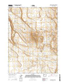
2014 Map of Lone Grave Butte
USGS Topo · Published 2014About this map
Lone Grave Butte rises above the high desert of Lake County in this 2014 survey, anchoring a landscape shaped by intermittent water and volcanic geology. The topographic detail reveals a network of seasonal drainages, including Guano Slough which snakes through the wide Guano Valley and into the steep-walled Guano Canyon to the northwest. The drainage patterns here imply a delicate desert hydrology, where even small features like the Lone Grave Waterhole and Rock Spg were vital landmarks for navigation and survival in this arid territory.
Find a feature on this map
15 named features on this map. Tap any name to fly to it.
Don’t see what you’re looking for? This feature index may not catch every label — zoom into the map to look around manually.
Map Details
Editions of this 2014 Lone Grave Butte Map
This is the sole edition of this map. No revisions or reprints were ever made.
Other maps of this area

1955 · Adel
USGS Topo · 1:250,000

1957 · Adel
USGS Topo · 1:250,000

1958 · Adel
USGS Topo · 1:250,000

1962 · Adel
USGS Topo · 1:250,000

1967 · Alger Lake
USGS Topo · 1:24,000

1967 · Swede Knoll
USGS Topo · 1:24,000

1968 · Guano Lake
USGS Topo · 1:24,000

1971 · Beatys Butte
USGS Topo · 1:24,000

1971 · Mahogany Butte
USGS Topo · 1:24,000
1971 · Beatys Butte NW
USGS Topo · 1:24,000