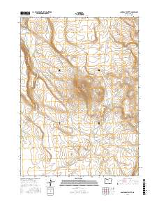
2017 Map of Lone Grave Butte
USGS Topo · Published 2017About this map
Lone Grave Butte and the broad expanse of Guano Valley characterize this high-desert landscape in Lake County. The terrain is marked by traditional cattle-country landmarks, suggesting a long history of ranching and movement through the Great Basin. Drainage patterns are defined by the intermittent Guano Slough and the carved depths of Guano Canyon, which drop away from the surrounding plateaus. Connectivity in this isolated region relies on the north-south artery of Beatys Butte Rd, which provides access to essential resources like the Lone Grave Waterhole. Near the eastern boundary, Buckaroo Pass and West Road Gulch indicate established routes through the rimrock, likely utilized by generations of buckaroos and early settlers navigating this part of Oregon.
Find a feature on this map
12 named features on this map. Tap any name to fly to it.
Don’t see what you’re looking for? This feature index may not catch every label — zoom into the map to look around manually.
Map Details
Editions of this 2017 Lone Grave Butte Map
This is the sole edition of this map. No revisions or reprints were ever made.
Other maps of this area

1955 · Adel
USGS Topo · 1:250,000

1957 · Adel
USGS Topo · 1:250,000

1958 · Adel
USGS Topo · 1:250,000

1962 · Adel
USGS Topo · 1:250,000

1967 · Alger Lake
USGS Topo · 1:24,000

1967 · Swede Knoll
USGS Topo · 1:24,000

1968 · Guano Lake
USGS Topo · 1:24,000

1971 · Beatys Butte
USGS Topo · 1:24,000

1971 · Mahogany Butte
USGS Topo · 1:24,000
1971 · Beatys Butte NW
USGS Topo · 1:24,000