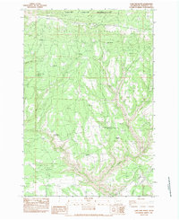
1983 Map of Lone Pine Butte
USGS Topo · Published 1983About this map
Simcoe Mountains terrain dominates this 1983 survey, where high ridges and deep canyons define the landscape of south-central Washington. The northern portion of the sheet is occupied by the Yakima Indian Reservation, marked by the prominent Bickleton Ridge and the Lookout House landmark. The mapping reveals a sparse network of high-altitude landmarks, including Lone Pine Butte and Tumwater Butte, which likely served as critical orientation points for range management and forestry in this period.
Find a feature on this map
21 named features on this map. Tap any name to fly to it.
Don’t see what you’re looking for? This feature index may not catch every label — zoom into the map to look around manually.
Map Details
Editions of this 1983 Lone Pine Butte Map
This is the sole edition of this map. No revisions or reprints were ever made.
Other maps of this area

1910 · Zillah
USGS Topo · 1:125,000

1916 · Arlington
USGS Topo · 1:125,000

1937 · White Swan
USGS Topo · 1:125,000

1950 · Yakima
USGS Topo · 1:250,000

1953 · The Dalles
USGS Topo · 1:250,000

1956 · The Dalles
USGS Topo · 1:250,000

1957 · The Dalles
USGS Topo · 1:250,000

1957 · Satus Pass
USGS Topo · 1:62,500

1958 · Yakima
USGS Topo · 1:250,000

1961 · Yakima
USGS Topo · 1:250,000