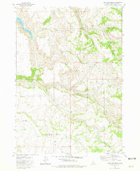
1981 Map of Lone Pine Ridge
USGS Topo · Published 1981About this map
Dehlin (Site) sits at the base of prominent terrain in this eastern Idaho landscape, where the headwaters of numerous forks and creeks carve through the high country. The topography is defined by significant elevations such as Big Horse Butte, Little Horse Butte, and Red Butte, which overlook a complex network of drainages including Bulls Fork and Indian Fork. To the north, the waters of Willow Creek gather into Ririe Lake, a notable feature of the local watershed. The drainage patterns around Lone Pine Ridge and Skelly Hill reveal a territory primarily utilized for ranching and resource management in the late twentieth century, characterized by the absence of dense modern settlements in favor of remote landmarks and high-altitude ridges.
Find a feature on this map
16 named features on this map. Tap any name to fly to it.
Don’t see what you’re looking for? This feature index may not catch every label — zoom into the map to look around manually.
Map Details
Editions of this 1981 Lone Pine Ridge Map
This is the sole edition of this map. No revisions or reprints were ever made.
Other maps of this area

1924 · Hell Creek
USGS Topo · 1:62,500

1924 · Ammon
USGS Topo · 1:62,500

1926 · Hell Creek
USGS Topo · 1:62,500

1950 · Rigby
USGS Topo · 1:62,500

1950 · Rigby SE
USGS Topo · 1:24,000

1951 · Rigby SE
USGS Topo · 1:24,000

1951 · Poplar
USGS Topo · 1:24,000

1951 · Heise SE
USGS Topo · 1:24,000

1955 · Driggs
USGS Topo · 1:250,000

1958 · Driggs
USGS Topo · 1:250,000