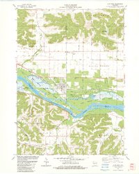
1983 Map of Lone Rock
USGS Topo · Published 1983About this map
The Wisconsin River creates a broad, braided floodplain at the junction of Richland, Sauk, and Iowa counties, anchoring the village of Lone Rock. This early 1980s landscape is defined by the Chicago Milwaukee St Paul and Pacific railroad corridor and the extensive wetlands of the Lower Wisconsin State Wildlife Area. To the north, the terrain transitions into the dissected bluffs of Bear Creek and Buena Vista, while the southern portion reveals the winding valley of Otter Creek. Genealogists and local historians can locate several rural landmarks, including Dixon Sch, Button Cem, and North Otter Creek Cem. The map illustrates the local infrastructure of the era, from the Tri County Airport to several hillside quarries and the prominent Long Island dividing the river's main channel.
Find a feature on this map
46 named features on this map. Tap any name to fly to it.
Don’t see what you’re looking for? This feature index may not catch every label — zoom into the map to look around manually.
Map Details
Editions of this 1983 Lone Rock Map
This is the sole edition of this map. No revisions or reprints were ever made.
Other maps of this area

1905 · Richland Center
USGS Topo · 1:125,000

1958 · La Crosse
USGS Topo · 1:250,000

1960 · Richland Center
USGS Topo · 1:62,500

1960 · Plain
USGS Topo · 1:62,500

1960 · Muscoda
USGS Topo · 1:62,500

1960 · Spring Green
USGS Topo · 1:62,500

1961 · La Crosse
USGS Topo · 1:250,000

1965 · La Crosse
USGS Topo · 1:250,000

1976 · La Crosse
USGS Topo · 1:250,000
1983 · Pleasant Ridge
USGS Topo · 1:24,000