
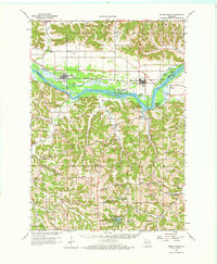
1960 Map of Spring Green
USGS Topo · Published 1962About this map
The Wisconsin River dominates the center of this landscape, its broad course weaving between numerous islands and sloughs such as Metcalf Island, Long Island, and Hutter Slough. To the north and south, the terrain transitions into complex networks of ridges and valleys, where the agricultural and social life of the 1960s is preserved through dozens of rural schools and churches. Many of these, like Hillside Sch near the river and Five Point Sch in the southern hills, represent a localized educational system during an era of rural consolidation.
Find a feature on this map
79 named features on this map. Tap any name to fly to it.
Don’t see what you’re looking for? This feature index may not catch every label — zoom into the map to look around manually.
Map Details
Editions of this 1960 Spring Green Map
2 editions found
Other maps of this area

1901 · Denzer
USGS Topo · 1:62,500

1902 · Mineral Point
USGS Topo · 1:125,000

1905 · Richland Center
USGS Topo · 1:125,000

1920 · Blue Mounds
USGS Topo · 1:62,500

1922 · Blue Mounds
USGS Topo · 1:62,500

1923 · Blanchardville
USGS Topo · 1:62,500

1952 · Dodgeville
USGS Topo · 1:24,000

1952 · Linden
USGS Topo · 1:24,000

1954 · Rockford
USGS Topo · 1:250,000

1955 · Rockford
USGS Topo · 1:250,000