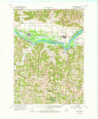
1960 Map of Spring Green
USGS Topo · Published 1971About this map
The Wisconsin River defines the central geography of this 1960s landscape, winding past the village of Spring Green and the riverfront settlement of Lone Rock. This survey documents a transition in land use, where established riverside towns and small farming communities like Clyde and Wyoming sit alongside developing recreation areas such as Tower Hill State Park and the expansive Governor Dodge State Park to the south. Numerous rural institutions are visible, including the Old Helena Cem and Unity Chapel, alongside a dense network of one-room schoolhouses like Yagers Corner Sch and Gold Mine Sch. The topography is marked by deeply carved drainages like Lowery Valley and Penn Hollow, reflecting the region’s unglaciated driftless character. The tracks of the Chicago Milwaukee St Paul and Pacific railroad parallel the river, serving as a vital transport corridor for this pocket of Sauk and Iowa counties.
Find a feature on this map
92 named features on this map. Tap any name to fly to it.
Don’t see what you’re looking for? This feature index may not catch every label — zoom into the map to look around manually.
Map Details
Editions of this 1960 Spring Green Map
2 editions found

Other maps of this area

1901 · Denzer
USGS Topo · 1:62,500

1902 · Mineral Point
USGS Topo · 1:125,000

1905 · Richland Center
USGS Topo · 1:125,000

1920 · Blue Mounds
USGS Topo · 1:62,500

1922 · Blue Mounds
USGS Topo · 1:62,500

1923 · Blanchardville
USGS Topo · 1:62,500

1952 · Dodgeville
USGS Topo · 1:24,000

1952 · Linden
USGS Topo · 1:24,000

1954 · Rockford
USGS Topo · 1:250,000

1955 · Rockford
USGS Topo · 1:250,000