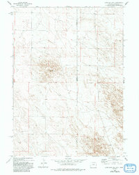
1978 Map of Lone Sand Hill
USGS Topo · Published 1993About this map
Wyoming and Nebraska share a quiet, high-plains border on this topographic survey, where the landscape is defined by the subtle rising contours of the Great Plains. The most prominent landmark is Lone Sand Hill, a distinctive topographic feature situated near the center of the sheet. This area is characterized by vast open spaces and sparse industrial activity, represented primarily by a single Well located in the northwestern portion of the quadrangle. The map captures the geometric precision of the Goshen and Sioux County boundary as it intersects with the state line, illustrating the methodical township and range system that organized this section of the American West. There are no major settlements or significant drainage systems noted, reflecting a landscape that remained largely unpopulated and dedicated to ranching or resource extraction at the time of the field inspection.
Find a feature on this map
4 named features on this map. Tap any name to fly to it.
Don’t see what you’re looking for? This feature index may not catch every label — zoom into the map to look around manually.
Map Details
Editions of this 1978 Lone Sand Hill Map
2 editions found
Other maps of this area

1896 · Patrick
USGS Topo · 1:125,000

1899 · Whistle Creek
USGS Topo · 1:125,000

1954 · Torrington
USGS Topo · 1:250,000

1955 · Alliance
USGS Topo · 1:250,000

1957 · Alliance
USGS Topo · 1:250,000

1958 · Torrington
USGS Topo · 1:250,000

1958 · Alliance
USGS Topo · 1:250,000

1974 · Spoon Butte SW
USGS Topo · 1:24,000

1974 · Spoon Butte
USGS Topo · 1:24,000

1977 · Van Tassell SE
USGS Topo · 1:24,000