
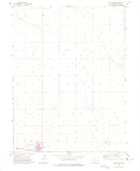
1972 Map of Lone Star
USGS Topo · Published 1975About this map
Lone Star serves as a central reference point in this corner of Northeastern Colorado, where the high plains landscape is defined by the ephemeral flow of several regional waterways. The drainage patterns of Rock Creek, Red Willow Creek, and Surveyor Creek dictate the topography, carving shallow valleys through the terrain. The map documents a sparsely populated rural district where agricultural infrastructure and natural resource extraction are primary features, evidenced by several Gravel Pit sites and a prominent Pipeline cutting across the southern sections.
Find a feature on this map
10 named features on this map. Tap any name to fly to it.
Don’t see what you’re looking for? This feature index may not catch every label — zoom into the map to look around manually.
Map Details
Editions of this 1972 Lone Star Map
This is the sole edition of this map. No revisions or reprints were ever made.
Other maps of this area

1954 · Sterling
USGS Topo · 1:250,000

1958 · Sterling
USGS Topo · 1:250,000

1972 · Clarkville
USGS Topo · 1:24,000

1972 · New Haven
USGS Topo · 1:24,000

1972 · Glacken Hill
USGS Topo · 1:24,000

1972 · Otis
USGS Topo · 1:24,000

1972 · Hyde
USGS Topo · 1:24,000

1972 · Clarkville SW
USGS Topo · 1:24,000

1972 · Burdett
USGS Topo · 1:24,000
1972 · Yuma North
USGS Topo · 1:24,000