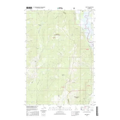
2017 Map of Lone Tree
USGS Topo · Published 2017About this map
Payette National Forest and Boise National Forest meet in this mountain landscape, defined by the drainage divide between the Middle Fork Weiser River and the Little Weiser River. The eastern edge of the quadrangle drops into the high-altitude Long Valley basin, where the waters of Lake Cascade dominate the valley floor. This 2017 survey details a network of forest development roads, such as Nat For Dev Rd 186 and Nat For Dev Rd 218, that provide access to high-elevation terrain features like No Business Canyon, White Licks, and Hubbard Basin. The topography is marked by prominent peaks and ridges, including Lone Tree, Mica Hill, and Mica Ridge, illustrating the complex watershed system that feeds both the Weiser River and the Payette River drainage systems.
Find a feature on this map
47 named features on this map. Tap any name to fly to it.
Don’t see what you’re looking for? This feature index may not catch every label — zoom into the map to look around manually.
Map Details
Editions of this 2017 Lone Tree Map
This is the sole edition of this map. No revisions or reprints were ever made.
Other maps of this area

1911 · Meadows
USGS Topo · 1:125,000

1954 · Council
USGS Topo · 1:62,500

1954 · New Meadows
USGS Topo · 1:62,500

1954 · Cascade
USGS Topo · 1:62,500

1955 · Baker
USGS Topo · 1:250,000

1959 · Baker
USGS Topo · 1:250,000
1973 · No Business Mtn
USGS Topo · 1:24,000
1973 · Lake Fork
USGS Topo · 1:24,000

1980 · McCall
USGS Topo · 1:100,000
1985 · Cold Spring Ridge
USGS Topo · 1:24,000