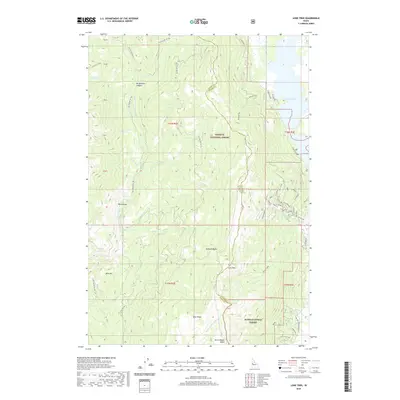
2020 Map of Lone Tree
USGS Topo · Published 2020About this map
Payette National Forest and Boise National Forest meet along a prominent ridgeline that also serves as the boundary between Adams and Valley counties. The terrain is defined by dramatic elevation changes, dropping from the heights of Mica Ridge and Mica Hill down toward the Lake Cascade shoreline. The hydrologic system is complex, with the Middle Fork Weiser River draining the western slopes while numerous small tributaries like Poison Cr and Little Cr flow eastward. High-altitude features such as Poison Lake, Hubbard Basin, and Burnt Wagon Basin suggest a landscape shaped by seasonal water and traditional movement through the backcountry. A network of specialized roads and trails, including Smokejumper and Johnson Way, provides access to these high basins and the western edge of the reservoir.
Find a feature on this map
59 named features on this map. Tap any name to fly to it.
Don’t see what you’re looking for? This feature index may not catch every label — zoom into the map to look around manually.
Map Details
Editions of this 2020 Lone Tree Map
This is the sole edition of this map. No revisions or reprints were ever made.
Other maps of this area

1911 · Meadows
USGS Topo · 1:125,000

1954 · Council
USGS Topo · 1:62,500

1954 · New Meadows
USGS Topo · 1:62,500

1954 · Cascade
USGS Topo · 1:62,500

1955 · Baker
USGS Topo · 1:250,000

1959 · Baker
USGS Topo · 1:250,000
1973 · No Business Mtn
USGS Topo · 1:24,000
1973 · Lake Fork
USGS Topo · 1:24,000

1980 · McCall
USGS Topo · 1:100,000
1985 · Cold Spring Ridge
USGS Topo · 1:24,000