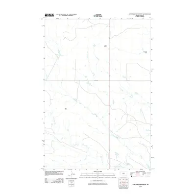
2012 Map of Lone Tree Draw West
USGS Topo · Published 2012About this map
The S Fork Moreau River meanders through this western Butte County landscape, defining the drainage patterns of a region characterized by prominent geological rises and ephemeral waterways. Elevated landmarks such as Crow Buttes and Macy Butte provide significant orientation points across the terrain, while the courses of Hay Cr and Spur Cr weave between the rises to join the river system. The map documents a shift in regional transit, marking the alignments of Old Hwy 85 and Old Hwy 79. These routes, alongside the namesake Lone Tree Draw, illustrate the enduring ranching and transit infrastructure of this part of the Great Plains as it appeared in the early 21st century.
Find a feature on this map
8 named features on this map. Tap any name to fly to it.
Don’t see what you’re looking for? This feature index may not catch every label — zoom into the map to look around manually.
Map Details
Editions of this 2012 Lone Tree Draw West Map
This is the sole edition of this map. No revisions or reprints were ever made.
Other maps of this area

1935 · Hoover
USGS Topo · 1:125,000

1935 · Harding
USGS Topo · 1:125,000

1954 · Lemmon
USGS Topo · 1:250,000

1957 · Lemmon
USGS Topo · 1:250,000

1973 · Lone Tree Draw East
USGS Topo · 1:24,000

1973 · Lone Tree Draw West
USGS Topo · 1:24,000
1973 · Antelope Creek East
USGS Topo · 1:24,000

1973 · Redig
USGS Topo · 1:24,000
1973 · Haystack Butte
USGS Topo · 1:24,000
1977 · Antelope Creek West
USGS Topo · 1:24,000