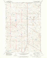
1973 Map of Antelope Creek East
USGS Topo · Published 1977About this map
The Moreau River and its tributary, the South Fork Moreau River, define the northern drainage patterns of this Butte County landscape. Surveyed in the early 1970s, the terrain is shaped by several major watercourses, including the westward-flowing Battle Creek and Fourmile Creek. The map documents a sparsely settled ranching region characterized by a network of unimproved roads and sectional fence lines that cross the high ground between the drainage basins. A localized Gravel Pit near Battle Creek provides one of the few indicators of industrial activity in this stretch of the western South Dakota plains. The map also records the prominent elevation of Four Mile in the west-central portion, illustrating the transition from the river bottomlands to the higher plateau.
Find a feature on this map
7 named features on this map. Tap any name to fly to it.
Don’t see what you’re looking for? This feature index may not catch every label — zoom into the map to look around manually.
Map Details
Editions of this 1973 Antelope Creek East Map
This is the sole edition of this map. No revisions or reprints were ever made.
Other maps of this area

1906 · Two Top
USGS Topo · 1:62,500

1907 · Belle Fourche
USGS Topo · 1:125,000

1913 · Newell
USGS Topo · 1:125,000

1935 · Hoover
USGS Topo · 1:125,000

1935 · Harding
USGS Topo · 1:125,000

1953 · Rapid City
USGS Topo · 1:250,000

1954 · Lemmon
USGS Topo · 1:250,000

1957 · Lemmon
USGS Topo · 1:250,000

1957 · Rapid City
USGS Topo · 1:250,000
1965 · Two Top Butte West
USGS Topo · 1:24,000