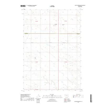
2017 Map of Lone Tree Draw West
USGS Topo · Published 2017About this map
S Fork Moreau River meanders across this High Plains landscape, a critical water source in an area defined by its drainage systems and prominent landmarks. The terrain is punctuated by significant elevations like Crow Buttes and Macy Butte, which provide navigational reference points across the vast stretches of Butte County. Transportation history is etched into the map through decommissioned routes such as Old US Hwy 85 and Old State Hwy 79, marking the transition of regional travel before modern realignments. The drainage network is further detailed by Spur Cr, Hay Cr, and the namesake Lone Tree Draw, reflecting the importance of every seasonal watercourse in this cattle-ranching region. These features collectively illustrate the geography of the Harding County and Butte County border, where land survey sections and township lines govern the legal landscape of South Dakota.
Find a feature on this map
14 named features on this map. Tap any name to fly to it.
Don’t see what you’re looking for? This feature index may not catch every label — zoom into the map to look around manually.
Map Details
Editions of this 2017 Lone Tree Draw West Map
This is the sole edition of this map. No revisions or reprints were ever made.
Other maps of this area

1935 · Hoover
USGS Topo · 1:125,000

1935 · Harding
USGS Topo · 1:125,000

1954 · Lemmon
USGS Topo · 1:250,000

1957 · Lemmon
USGS Topo · 1:250,000

1973 · Lone Tree Draw East
USGS Topo · 1:24,000

1973 · Lone Tree Draw West
USGS Topo · 1:24,000
1973 · Antelope Creek East
USGS Topo · 1:24,000

1973 · Redig
USGS Topo · 1:24,000
1973 · Haystack Butte
USGS Topo · 1:24,000
1977 · Antelope Creek West
USGS Topo · 1:24,000