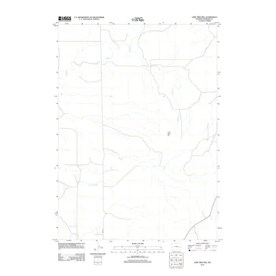
2012 Map of Lone Tree Hill
USGS Topo · Published 2012About this map
Lone Tree Hill serves as the namesake landmark for this expanse of Niobrara County, anchoring a drainage network defined by the serpentine courses of Muddy Cr and Little Muddy Cr. In this early twenty-first-century survey, the landscape remains largely open and rural, following the natural hydrology of the region toward the south where Willow Cr crosses the terrain. Human intervention is sparse, represented primarily by the straight-line utility of local transportation routes such as Jireh Rd. The map illustrates a high-plains environment where water sources dictate the geography, highlighting the contrast between the winding creek beds and the prominent elevation of Lone Tree Hill.
Find a feature on this map
5 named features on this map. Tap any name to fly to it.
Don’t see what you’re looking for? This feature index may not catch every label — zoom into the map to look around manually.
Map Details
Editions of this 2012 Lone Tree Hill Map
This is the sole edition of this map. No revisions or reprints were ever made.
Other maps of this area

1949 · Cedar Top
USGS Topo · 1:24,000

1950 · Cedar Top
USGS Topo · 1:24,000

1950 · Prairie View School
USGS Topo · 1:24,000

1954 · Torrington
USGS Topo · 1:250,000

1958 · Torrington
USGS Topo · 1:250,000

1970 · Keeline
USGS Topo · 1:24,000

1974 · Lone Tree Hill
USGS Topo · 1:24,000

1974 · Silver Springs
USGS Topo · 1:24,000
1978 · Meadowdale
USGS Topo · 1:24,000
1978 · Rawhide Buttes West
USGS Topo · 1:24,000