
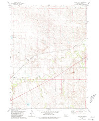
1980 Map of Lone Tree Ranch
USGS Topo · Published 1981About this map
Lone Tree Ranch and Felt Ranch anchor this landscape along the border of Dawes County, Nebraska, and Fall River County, South Dakota. The area is defined by a dense network of intermittent drainage channels and creeks that carve through the prairie, including Lone Tree Creek, Messenger Creek, and Fisher Creek. These waterways, though often seasonal, dictated the placement of early ranching operations and water management features like the numerous tanks scattered across the quadrangle.
Find a feature on this map
12 named features on this map. Tap any name to fly to it.
Don’t see what you’re looking for? This feature index may not catch every label — zoom into the map to look around manually.
Map Details
Editions of this 1980 Lone Tree Ranch Map
This is the sole edition of this map. No revisions or reprints were ever made.
Other maps of this area

1896 · Oelrichs
USGS Topo · 1:125,000

1900 · Oelrichs
USGS Topo · 1:125,000

1955 · Hot Springs
USGS Topo · 1:250,000

1955 · Alliance
USGS Topo · 1:250,000

1957 · Alliance
USGS Topo · 1:250,000

1958 · Alliance
USGS Topo · 1:250,000

1980 · Horn
USGS Topo · 1:24,000

1980 · Wolf Butte
USGS Topo · 1:24,000

1980 · Wayside
USGS Topo · 1:24,000
1980 · Trunk Butte
USGS Topo · 1:24,000