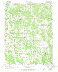
1969 Map of Lonedell
USGS Topo · Published 1971About this map
Meramec River and Big River converge in this corner of the Missouri Ozarks, framing a landscape of rural school districts and family cemeteries. The small settlements of Lonedell and Luebbering serve as local hubs for a community defined by its watercourses and ridges. Local genealogy is well-preserved through numerous family landmarks, including Finney Cem, Drake Cem, and Woodcock Cem. The presence of School R-14 and several country churches like Fairview Ch and Mt Olive Ch illustrates the social fabric of Franklin County in the late 1960s. High ground is marked by the Lonedell Lookout Tower, overlooking a mix of dense woodland and the open terrain of Prairie. This survey captures the area just as modern infrastructure began to weave through the older river-and-road network of east-central Missouri.
Find a feature on this map
27 named features on this map. Tap any name to fly to it.
Don’t see what you’re looking for? This feature index may not catch every label — zoom into the map to look around manually.
Map Details
Editions of this 1969 Lonedell Map
2 editions found
Other maps of this area

1901 · De Soto
USGS Topo · 1:125,000

1937 · Pacific
USGS Topo · 1:24,000

1937 · Fletcher
USGS Topo · 1:24,000

1938 · Cedar Hill
USGS Topo · 1:24,000

1938 · Fletcher
USGS Topo · 1:24,000

1940 · Cedar Hill
USGS Topo · 1:24,000

1946 · Richwoods
USGS Topo · 1:62,500

1947 · St. Clair
USGS Topo · 1:62,500

1948 · Richwoods
USGS Topo · 1:62,500

1949 · Saint Louis
USGS Topo · 1:250,000