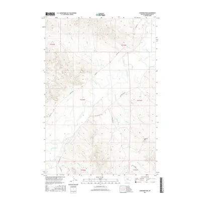
2017 Map of Lonesome Peak
USGS Topo · Published 2017About this map
Powder River meanders through the heart of this landscape, its wide valley floor serving as the primary corridor for movement and water in an otherwise arid expanse. The elevation is anchored by Lonesome Peak in the southeast, a prominent landmark that rises above the intricate network of drainage systems. This drainage pattern is remarkably dense, with descriptively named waterways such as Baking Powder Cr, Bog Springs Cr, and Dripping Spring Cr carving deep into the terrain. Human presence is marked by a sparse network of gravel and unimproved roads, including Moorhead Rd and Big Powder River E Rd, which follow the contours of the river and the higher ridges. The inclusion of Garr Reservoir and several named gulches and springs highlights the essential nature of water management for ranching and survival in this corner of Powder River County.
Find a feature on this map
28 named features on this map. Tap any name to fly to it.
Don’t see what you’re looking for? This feature index may not catch every label — zoom into the map to look around manually.
Map Details
Editions of this 2017 Lonesome Peak Map
This is the sole edition of this map. No revisions or reprints were ever made.
Other maps of this area

1954 · Ekalaka
USGS Topo · 1:250,000

1956 · Ekalaka
USGS Topo · 1:250,000

1958 · Ekalaka
USGS Topo · 1:250,000

1965 · Ekalaka
USGS Topo · 1:250,000

1970 · Baldy Peak
USGS Topo · 1:24,000

1970 · Huckins School
USGS Topo · 1:24,000

1970 · Bear Skull Mountain
USGS Topo · 1:24,000

1973 · Lonesome Peak
USGS Topo · 1:24,000
1973 · Yarger Butte
USGS Topo · 1:24,000
1973 · Eldon Mountain
USGS Topo · 1:24,000