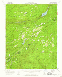
1956 Map of Long Barn
USGS Topo · Published 1959About this map
Stanislaus National Forest dominates this mid-century survey, revealing a landscape defined by timber extraction and the burgeoning water infrastructure of Tuolumne County. The intricate network of a Logging Railroad snakes through the northern hills near Grohl Meadow, supporting the region's industrial base alongside numerous mining operations like the Red Cloud Mine and the Thunderbolt Mine.
Find a feature on this map
99 named features on this map. Tap any name to fly to it.
Don’t see what you’re looking for? This feature index may not catch every label — zoom into the map to look around manually.
Map Details
Editions of this 1956 Long Barn Map
3 editions found
Other maps of this area

1891 · Big Trees
USGS Topo · 1:125,000

1893 · Sonora
USGS Topo · 1:125,000

1894 · Big Trees
USGS Topo · 1:125,000

1896 · Dardanelles
USGS Topo · 1:125,000

1896 · Sonora
USGS Topo · 1:125,000

1897 · Sonora
USGS Topo · 1:125,000

1897 · Big Trees
USGS Topo · 1:125,000

1897 · Yosemite
USGS Topo · 1:125,000

1898 · Dardanelles
USGS Topo · 1:125,000

1898 · Sonora
USGS Topo · 1:125,000