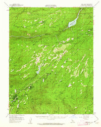
1956 Map of Long Barn
USGS Topo · Published 1962About this map
The Stanislaus National Forest landscape in the mid-1950s was a hub of timber production and high-country recreation, as evidenced by the extensive Logging Railroad winding through the northern ridges. The development of water infrastructure is centrally featured, with the recently completed Beardsley Lake and its associated Beardsley Dam on the Middle Fork Stanislaus River, alongside the Lyons Reservoir further south. These engineering projects supported growing communities like Mi-Wuk Village and Twain Harte, which were transitioning from logging camps to seasonal and year-round mountain retreats. Scattered throughout the basin, legacy operations such as the Hess Mill (Site) and the Casa Madera Mine point to a history of resource extraction that shaped the rugged geography of Dodge Ridge and Hull Creek Ridge.
Find a feature on this map
76 named features on this map. Tap any name to fly to it.
Don’t see what you’re looking for? This feature index may not catch every label — zoom into the map to look around manually.
Map Details
Editions of this 1956 Long Barn Map
3 editions found
Other maps of this area

1891 · Big Trees
USGS Topo · 1:125,000

1893 · Sonora
USGS Topo · 1:125,000

1894 · Big Trees
USGS Topo · 1:125,000

1896 · Dardanelles
USGS Topo · 1:125,000

1896 · Sonora
USGS Topo · 1:125,000

1897 · Sonora
USGS Topo · 1:125,000

1897 · Big Trees
USGS Topo · 1:125,000

1897 · Yosemite
USGS Topo · 1:125,000

1898 · Dardanelles
USGS Topo · 1:125,000

1898 · Sonora
USGS Topo · 1:125,000