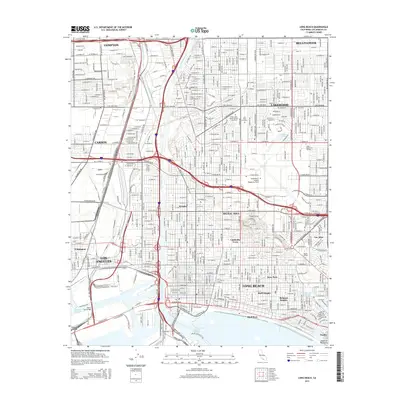
2015 Map of Long Beach
USGS Topo · Published 2015About this map
Signal Hill rises above the urban grid of the South Bay, anchoring a landscape defined by the heavy infrastructure of the Los Angeles River and Los Angeles Harbor. This 2015 perspective details the high-density residential and commercial corridors of Long Beach, including neighborhoods like Cambodia Town, Rose Park, and the seaside community of Naples. The map illustrates the complex intersection of aviation and education, showing the proximity of the Long Beach Airport /Daugherty Field to institutions like Long Beach City College. From the industrial zones of Terminal Island, linked by the Henry Ford Bridge, to the quiet residential blocks of Lakewood and Bellflower, the survey provides an exhaustive record of the modern Southern California built environment. Water management is central to the layout, with Compton Creek and the Cerritos Channel integrated into the city’s industrial and recreational fabric.
Find a feature on this map
173 named features on this map. Tap any name to fly to it.
Don’t see what you’re looking for? This feature index may not catch every label — zoom into the map to look around manually.
Map Details
Editions of this 2015 Long Beach Map
This is the sole edition of this map. No revisions or reprints were ever made.
Other maps of this area

1896 · Redondo
USGS Topo · 1:62,500

1896 · Las Bolsas
USGS Topo · 1:62,500

1896 · San Pedro
USGS Topo · 1:62,500

1896 · Downey
USGS Topo · 1:62,500

1899 · Downey
USGS Topo · 1:62,500

1901 · Southern California Sheet No. 1
USGS Topo · 1:250,000

1902 · Downey
USGS Topo · 1:62,500

1904 · Southern California Sheet No. 1
USGS Topo · 1:250,000

1923 · Wilmington
USGS Topo · 1:24,000
1924 · Compton
USGS Topo · 1:24,000