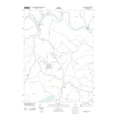
2013 Map of Long Eddy
USGS Topo · Published 2013About this map
The Delaware River carves a winding path along the border of Pennsylvania and New York, anchoring a landscape defined by small riverfront settlements and upland plateaus. Along the northern bends, the villages of Equinunk, Lordville, and Long Eddy serve as historic focal points where local roads like River Rd and Lordville Rd converge on the water. The terrain is marked by significant elevations such as Big Hickory and Jensen Hill, while the interior is dotted with recreational landmarks and seasonal retreats, including Indian Head Camp, Camp Blue Ridge, and Camp Equinunk. Drainage from these heights feeds into a complex network of tributaries like Little Equinunk Cr and Pea Brook. This 2013 survey illustrates a rural transition where traditional hamlets like Hilltown and Braman persist alongside significant water bodies such as Duck Harbor Pond and Margaret Lake.
Find a feature on this map
105 named features on this map. Tap any name to fly to it.
Don’t see what you’re looking for? This feature index may not catch every label — zoom into the map to look around manually.
Map Details
Editions of this 2013 Long Eddy Map
This is the sole edition of this map. No revisions or reprints were ever made.
Other maps of this area

1892 · Honesdale
USGS Topo · 1:62,500

1920 · Long Eddy
USGS Topo · 1:62,500

1920 · Damascus
USGS Topo · 1:62,500

1921 · Long Eddy
USGS Topo · 1:48,000

1923 · Damascus
USGS Topo · 1:62,500

1923 · Long Eddy
USGS Topo · 1:62,500

1924 · Starrucca
USGS Topo · 1:48,000

1926 · Starrucca
USGS Topo · 1:62,500

1930 · Starrucca
USGS Topo · 1:48,000

1933 · Starrucca
USGS Topo · 1:62,500