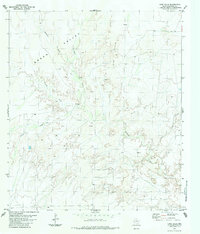
1983 Map of Long Hills
USGS Topo · Published 1984About this map
Green Valley and the prominent Long Hills define this expanse of Brewster County, where water drainage patterns reveal a complex landscape of draws and seasonal creeks. The terrain is largely shaped by the winding course of Terlingua Creek, which receives several tributaries including Musgrave Creek, Crystal Creek, and Hale Creek. This 1983 survey shows a region largely defined by its natural geography rather than dense development, with activity centered on isolated sites like Burnt House Camp. Prospectors once traversed these hills, evidenced by scattered prospects and a singular prospect marked on the USGS sheet. A network of light-duty roads and a rugged Jeep Trail provide the primary means of navigating the arid valleys and steep slopes, while small tanks indicate the vital management of water in this remote Texas environment.
Find a feature on this map
13 named features on this map. Tap any name to fly to it.
Don’t see what you’re looking for? This feature index may not catch every label — zoom into the map to look around manually.
Map Details
Editions of this 1983 Long Hills Map
This is the sole edition of this map. No revisions or reprints were ever made.
Other maps of this area

1917 · Agua Fria
USGS Topo · 1:62,500

1917 · Tascotal Mesa
USGS Topo · 1:62,500

1917 · Buck Hill
USGS Topo · 1:62,500

1918 · Buck Hill
USGS Topo · 1:62,500

1918 · Jordan Gap
USGS Topo · 1:62,500

1925 · Buck Hill
USGS Topo · 1:62,500

1930 · Jordan Gap
USGS Topo · 1:62,500

1937 · Agua Fria
USGS Topo · 1:62,500

1944 · Tascotal Mesa
USGS Topo · 1:62,500

1959 · Emory Peak
USGS Topo · 1:250,000