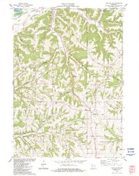
1983 Map of Long Hollow
USGS Topo · Published 1983About this map
Boscobel sits at the northern edge of this driftless region landscape, where the Lower Wisconsin River State Wildlife Area meets a complex network of deeply incised valleys and high ridges. The map reveals a rural economy shaped by topography, with numerous small quarries dotting the hillsides near Sanders Creek and Crooked Creek. Genealogists and local historians can find several established burial grounds across the townships of Marion, Hickory Grove, and Mount Ida, including Brechler Cem and Crown Hill Cem.
Find a feature on this map
61 named features on this map. Tap any name to fly to it.
Don’t see what you’re looking for? This feature index may not catch every label — zoom into the map to look around manually.
Map Details
Editions of this 1983 Long Hollow Map
This is the sole edition of this map. No revisions or reprints were ever made.
Other maps of this area

1900 · Lancaster
USGS Topo · 1:125,000

1904 · Lancaster
USGS Topo · 1:125,000

1908 · Lancaster
USGS Topo · 1:125,000

1926 · Wauzeka
USGS Topo · 1:62,500

1933 · Boscobel
USGS Topo · 1:62,500

1958 · La Crosse
USGS Topo · 1:250,000

1959 · Dubuque
USGS Topo · 1:250,000

1961 · Dubuque
USGS Topo · 1:250,000

1961 · La Crosse
USGS Topo · 1:250,000

1962 · Dubuque
USGS Topo · 1:250,000