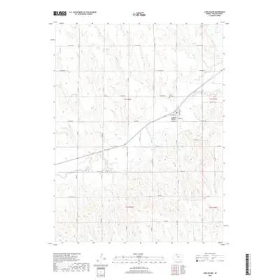
2018 Map of Long Island
USGS Topo · Published 2018About this map
Long Island serves as the central hub for this portion of Phillips County, situated where the high plains are dissected by the winding courses of Prairie Dog Cr and Elk Cr. The town's grid is clearly defined by landmarks such as Wheeling Ave and Commercial St, reflecting a well-organized prairie settlement pattern. Outside the immediate town limits, the landscape is etched with a network of rural roads following the Section Land Survey system, including W Buffalo Rd and W Hunter RD. Local genealogy and settlement history are anchored by two distinct burial sites: Long Island Cem located just northeast of the town center, and the more isolated Vineman Cem to the west. The drainage patterns of Hanson Cr and various unnamed draws illustrate the erosion-carved topography that defines this agricultural region of northern Kansas.
Find a feature on this map
25 named features on this map. Tap any name to fly to it.
Don’t see what you’re looking for? This feature index may not catch every label — zoom into the map to look around manually.
Map Details
Editions of this 2018 Long Island Map
This is the sole edition of this map. No revisions or reprints were ever made.
Other maps of this area

1893 · Norton
USGS Topo · 1:125,000

1893 · Phillipsburg
USGS Topo · 1:125,000

1896 · Holdrege
USGS Topo · 1:125,000

1896 · Arapahoe
USGS Topo · 1:125,000

1898 · Arapahoe
USGS Topo · 1:125,000

1955 · Grand Island
USGS Topo · 1:250,000

1955 · Beloit
USGS Topo · 1:250,000

1957 · Grand Island
USGS Topo · 1:250,000

1957 · Precept
USGS Topo · 1:24,000

1957 · Stamford SE
USGS Topo · 1:24,000