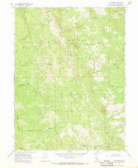
1967 Map of Long Ridge
USGS Topo · Published 1969About this map
The remote homesteads and ranches of the Six Rivers National Forest define this 1960s landscape in Trinity County. Named sites such as the Willie Hoaglin Place and the Bob Hoaglin Place are linked only by an intricate network of a Pack Trail and Jeep Trail, illustrating the isolation of high-country ranching before modern road development. The topography is dominated by the massive north-south spine of Long Ridge, which separates the drainages of Hoaglin Creek and Lightfoot Creek.
Find a feature on this map
34 named features on this map. Tap any name to fly to it.
Don’t see what you’re looking for? This feature index may not catch every label — zoom into the map to look around manually.
Map Details
Editions of this 1967 Long Ridge Map
This is the sole edition of this map. No revisions or reprints were ever made.
Other maps of this area

1920 · Covelo
USGS Topo · 1:62,500

1921 · Hoaglin
USGS Topo · 1:62,500

1922 · Island Mountain
USGS Topo · 1:62,500

1926 · Covelo
USGS Topo · 1:62,500

1931 · Hoaglin
USGS Topo · 1:96,000

1935 · Hoaglin
USGS Topo · 1:125,000

1952 · Spyrock
USGS Topo · 1:62,500

1952 · Covelo
USGS Topo · 1:62,500

1953 · Blackrock Mtn
USGS Topo · 1:62,500

1954 · Blackrock Mtn
USGS Topo · 1:62,500