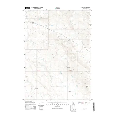
2013 Map of Long Valley
USGS Topo · Published 2013About this map
Hancock Ranch and the high basins of eastern Idaho define this landscape of high-altitude water management and volcanic geology. The presence of the Willow Creek Lava Field in the southern portion of the quadrangle highlights the region's recent geologic activity, contrasting with the numerous drainages such as Crane Cr and Sheep Cr that carve through the hills. Water is a central theme of this terrain, evident in the development of the Robison Reservoir and Parleys Reservoir, along with isolated sources like Dynamite Spring and Gold Spring. Prominent landmarks such as Mollies Nipple, Sheep Mtn, and the Three Buttes provide essential navigational points within the complex topography of the Long Valley. This mapping reveals a remote ranching and grazing territory where seasonal water flow and named terrain features like Cranes Flat dictate the use of the land.
Find a feature on this map
35 named features on this map. Tap any name to fly to it.
Don’t see what you’re looking for? This feature index may not catch every label — zoom into the map to look around manually.
Map Details
Editions of this 2013 Long Valley Map
This is the sole edition of this map. No revisions or reprints were ever made.
Other maps of this area

1917 · Cranes Flat
USGS Topo · 1:62,500

1918 · Paradise Valley
USGS Topo · 1:62,500

1924 · Hell Creek
USGS Topo · 1:62,500

1924 · Ammon
USGS Topo · 1:62,500

1926 · Hell Creek
USGS Topo · 1:62,500

1955 · Driggs
USGS Topo · 1:250,000

1958 · Driggs
USGS Topo · 1:250,000

1962 · Driggs
USGS Topo · 1:250,000
1963 · Bone
USGS Topo · 1:24,000
1981 · Meadow Creek Mtn
USGS Topo · 1:24,000