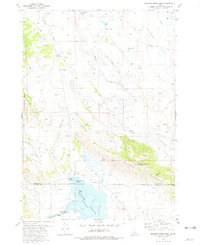
1981 Map of Meadow Creek Mtn
USGS Topo · Published 1981About this map
Blackfoot Reservoir dominates the southern landscape of this 1981 survey, where the Blackfoot River enters the basin near a local Gaging Station. The terrain is defined by the high ground of Meadow Creek Mountain and the Wilson Ridge, which separates the reservoir's northern reaches from the drainage of Meadow Creek and Crooked Creek Flat. This area illustrates a working high-country landscape, marked by seasonal livestock infrastructure like the Association Corral and Hansen Corral. Small, specific landmarks such as Meteor Hole and Moses Pass offer precise points of interest for local historians. Recreational and agricultural utility is evident in features like the Poison Creek Boat Ramp and numerous named springs that dot the slopes of the Blackfoot Mts and Paradise Hills.
Find a feature on this map
34 named features on this map. Tap any name to fly to it.
Don’t see what you’re looking for? This feature index may not catch every label — zoom into the map to look around manually.
Map Details
Editions of this 1981 Meadow Creek Mtn Map
This is the sole edition of this map. No revisions or reprints were ever made.
Other maps of this area

1914 · Henry
USGS Topo · 1:48,000

1916 · Henry
USGS Topo · 1:62,500

1917 · Portneuf
USGS Topo · 1:62,500

1917 · Cranes Flat
USGS Topo · 1:62,500

1918 · Paradise Valley
USGS Topo · 1:62,500

1955 · Driggs
USGS Topo · 1:250,000

1955 · Preston
USGS Topo · 1:250,000

1958 · Driggs
USGS Topo · 1:250,000

1958 · Preston
USGS Topo · 1:250,000

1962 · Driggs
USGS Topo · 1:250,000