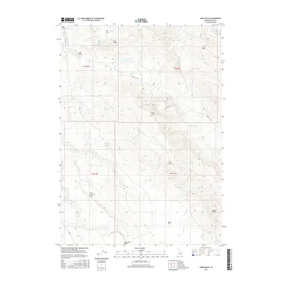
2017 Map of Long Valley
USGS Topo · Published 2017About this map
The Willow Creek Lava Field dominates the southwestern portion of this Idaho landscape, where the basaltic flows meet the high-altitude drainage systems of the Caribou Range. Water is the primary defining feature of this 2017 survey, with an intricate network of seasonal flows and managed water sources including Robison Reservoir and Parleys Reservoir. The terrain is marked by distinctive geological formations such as the steep Mollies Nipple and the broad The Basin, reflecting the complex volcanic and erosional history of Bingham County. Local travel is facilitated by Long Valley Rd and Bone Rd, which navigate the undulating topography between Outlet Ridge and the Pack Saddle Basin. The abundance of named springs, such as Dynamite Spring and Gold Spring, indicates the critical importance of these water points for livestock and land management in this high-desert environment.
Find a feature on this map
35 named features on this map. Tap any name to fly to it.
Don’t see what you’re looking for? This feature index may not catch every label — zoom into the map to look around manually.
Map Details
Editions of this 2017 Long Valley Map
This is the sole edition of this map. No revisions or reprints were ever made.
Other maps of this area

1917 · Cranes Flat
USGS Topo · 1:62,500

1918 · Paradise Valley
USGS Topo · 1:62,500

1924 · Hell Creek
USGS Topo · 1:62,500

1924 · Ammon
USGS Topo · 1:62,500

1926 · Hell Creek
USGS Topo · 1:62,500

1955 · Driggs
USGS Topo · 1:250,000

1958 · Driggs
USGS Topo · 1:250,000

1962 · Driggs
USGS Topo · 1:250,000
1963 · Bone
USGS Topo · 1:24,000
1981 · Meadow Creek Mtn
USGS Topo · 1:24,000