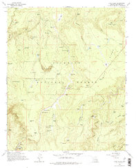
1965 Map of Long Valley
USGS Topo · Published 1975About this map
Coconino National Forest defines the rugged high-elevation landscape of this mid-1960s study, where the intersection of water resources and forest management is evident across the terrain. The small settlement at Clints Well serves as a central point, surrounded by a complex network of timber and grazing infrastructure. The area is dotted with dozens of earthen reservoirs or "tanks," such as Kelley Tank and Snafu Tank, highlighting the essential role of water catchment in this arid timberland.
Find a feature on this map
78 named features on this map. Tap any name to fly to it.
Don’t see what you’re looking for? This feature index may not catch every label — zoom into the map to look around manually.
Map Details
Editions of this 1965 Long Valley Map
3 editions found
Other maps of this area

1887 · Verde
USGS Topo · 1:250,000

1892 · Verde
USGS Topo · 1:250,000

1934 · Pine
USGS Topo · 1:62,500

1934 · Promontory Butte
USGS Topo · 1:62,500

1939 · Promontory Butte
USGS Topo · 1:62,500

1940 · Pine
USGS Topo · 1:62,500

1952 · Pine
USGS Topo · 1:62,500

1952 · Promontory Butte
USGS Topo · 1:62,500

1954 · Holbrook
USGS Topo · 1:250,000

1957 · Holbrook
USGS Topo · 1:250,000