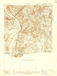
1933 Map of Longmeadow
USGS Topo · Published 1933About this map
The Connecticut River serves as the western boundary of this 1930s landscape, where Springfield and West Springfield are connected by the North End Bridge, Memorial Bridge, and South End Bridge. The industrial and educational character of the region is evident in the presence of Springfield College, American International College, and the sprawling Watershops Pond complex. Extensive rail infrastructure centers on Union Station, with the Boston & Albany and New York New Haven & Hartford lines facilitating the transport of goods and people. To the south, the transition into Longmeadow and East Longmeadow reveals a more suburban and agricultural pattern, punctuated by local landmarks like McCarthy Hill and the Quarry Pond at the edge of the Connecticut state line.
Find a feature on this map
61 named features on this map. Tap any name to fly to it.
Don’t see what you’re looking for? This feature index may not catch every label — zoom into the map to look around manually.
Map Details
Editions of this 1933 Longmeadow Map
This is the sole edition of this map. No revisions or reprints were ever made.
Other maps of this area

1886 · Springfield
USGS Topo · 1:62,500

1887 · Palmer
USGS Topo · 1:62,500

1889 · Springfield
USGS Topo · 1:62,500

1889 · Palmer
USGS Topo · 1:62,500

1892 · Hartford
USGS Topo · 1:62,500

1892 · Tolland
USGS Topo · 1:62,500

1893 · Springfield
USGS Topo · 1:62,500

1893 · Palmer
USGS Topo · 1:62,500

1895 · Springfield
USGS Topo · 1:62,500

1896 · Holyoke
USGS Topo · 1:125,000