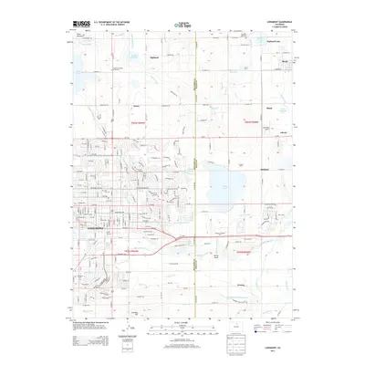
2013 Map of Longmont
USGS Topo · Published 2013About this map
The agricultural and suburban landscape of the Boulder and Weld County border area is defined by an intricate network of irrigation systems and residential expansion in this 2013 survey. Water management is central to the region, with the Oligarchy Ditch, Highland Ditch, and Supply Ditch feeding numerous reservoirs such as Calkins Reservoir and Highland Lake. The city of Longmont serves as the primary hub, showing a dense street grid that includes landmarks like Mtn View Cem and Sunset Park and Golf Course. Moving toward the northeastern corner, the landscape transitions to smaller settlements like Mead and Liberty, where industrial or agricultural sites such as Docheff Dairy and the Cartwheel Airport are situated. For those tracing local history, several memorial sites are noted, including Burlington Cem and Foothills Gardens of Memory, reflecting the long-established communities of the Saint Vrain Valley.
Find a feature on this map
204 named features on this map. Tap any name to fly to it.
Don’t see what you’re looking for? This feature index may not catch every label — zoom into the map to look around manually.
Map Details
Editions of this 2013 Longmont Map
This is the sole edition of this map. No revisions or reprints were ever made.
Other maps of this area

1902 · Greeley
USGS Topo · 1:125,000

1904 · Niwot
USGS Topo · 1:62,500

1906 · Loveland
USGS Topo · 1:62,500

1908 · Loveland
USGS Topo · 1:62,500

1949 · Gowanda
USGS Topo · 1:24,000

1950 · Frederick
USGS Topo · 1:24,000

1950 · Gowanda
USGS Topo · 1:24,000

1950 · Hygiene
USGS Topo · 1:24,000
1950 · Erie
USGS Topo · 1:24,000

1950 · Niwot
USGS Topo · 1:24,000