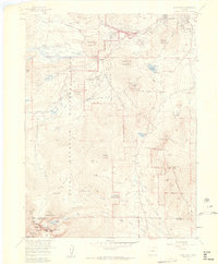
1957 Map of Longs Peak
USGS Topo · Published 1959About this map
Estes Park serves as the gateway to this high-altitude landscape where the complex terrain of Rocky Mountain National Park meets the Roosevelt National Forest. The map documents a mid-century period of recreation and water management, featuring landmarks like the Estes Park Conference Camp (YMCA) and the Aspen Creek Siphon. Significant elevation changes are detailed from the valley floors of Moraine Park up to the formidable heights of Twin Sisters Peaks and the technical features of the Boulder Field Trail leading toward the Keyhole. This survey preserves the mid-century layout of essential infrastructure, including the Moraine Park Museum and the Longs Peak Ranger Station and Campground, alongside remnants of industrial activity like the Eugene Mine and several gravel pits.
Find a feature on this map
82 named features on this map. Tap any name to fly to it.
Don’t see what you’re looking for? This feature index may not catch every label — zoom into the map to look around manually.
Map Details
Editions of this 1957 Longs Peak Map
2 editions found

Other maps of this area

1902 · Boulder
USGS Topo · 1:62,500

1904 · Boulder
USGS Topo · 1:62,500

1905 · Mount Olympus
USGS Topo · 1:62,500

1907 · Mount Olympus
USGS Topo · 1:62,500

1915 · Longs Peak
USGS Topo · 1:125,000

1919 · Rocky Mountain National Park
USGS Topo · 1:125,000

1954 · Greeley
USGS Topo · 1:250,000

1957 · Greeley
USGS Topo · 1:250,000

1957 · Mc Henrys Peak
USGS Topo · 1:24,000

1957 · Trail Ridge
USGS Topo · 1:24,000